
+51 963 748 762 | info@peruexperience.com

+51 963 748 762 | info@peruexperience.com
Below you will find different maps, ilustrating both the division of the country in geografical areas and the country’s biggest and most relevant cities for visiting.
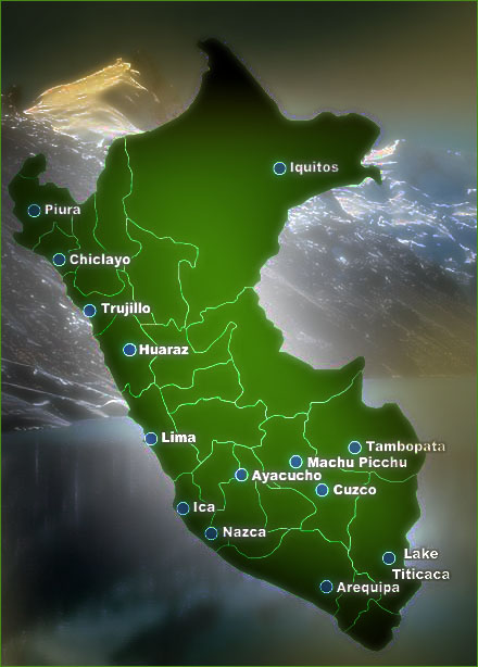 The most important cities and places in Peru: The most important cities and places in Peru:
Lima: Peru’s capital, also called “The City of Kings”. Population: approximately 9 mio. Cusco: The famous Inca capital, close to Machu Picchu (approximately 80 km as the crow flies). Very famous for beng the starting point for many trekking tours in Peru. Population: approximately 500.000 Arequipa: The second biggest city in Peru, also called “The White City. Population: approximately 900.000. Chiclayo: Peru’s fourth largest city, also called “The Heroic City”. Population: approximately: 740.000 Trujllo: Peru’s third largest city, also called “The City of Eternal Spring. Population: approximately: 800.000. Iquitos: City in the Amazon Rainforest, only accesible by boat or airplane. Population: approximately 500.000 Ayacucho: A city famous for its religious celebrations, especially during Easter, also called “The City of the Churches. Population: approximately 150.000. Machu Picchu: The world famous Inca ruins, today one of the world’s 7 modern wonders. Also called “The lost City of the Incas.” Lake Titicaca: The highest navigable lake in the world, having a surface area of 8,372 km2 (3,232 sq miles). The total volume is about 893 km3 (214 cu miles), the largest in South America. |
|
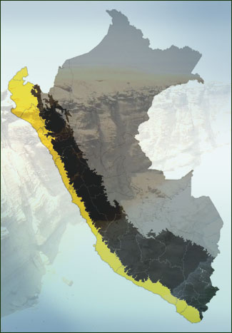
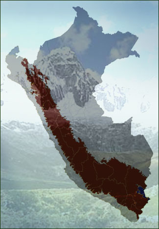
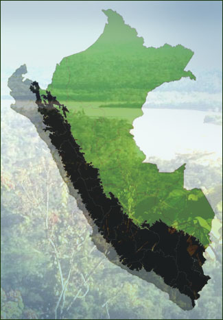
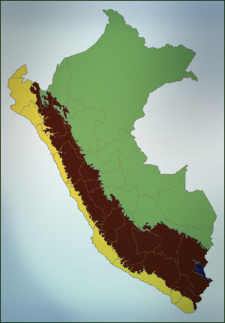 Peruvian geography Peruvian geography
The coast, jungle and mountains stretch across the entire country from North to South and divide Peru into three natural geographical areas. |
|
When to Travel to Peru
The seasons are opposite of those in Europe and the US, which means that summer in Peru lasts from December to the end of March, while winter lasts from June to the end of September. Generally, Peru’s winter is the best period for travel (since it is dry season), but it is certainly also possible to travel in Peru during summer. You simply need to consider when to go where. We are, of course, happy to help you plan your trips to Peru.
 The coast: The coast:
The arid coast runs along the Pacific Ocean, where you can find cliffs, peninsulas, bays and beaches. The climate is different on the coast, where summer has its peak between January and March. So if you enjoy a sunny beach holiday this is the perfect time period for traveling to Peru. Please be aware that temperatures in Lima and other major cities can get hot during the summer, and therefore it might be a good idea to spend more time on the beaches to escape the urban heat. Beginning in April, the temperature drops in the coastal areas and around Lima a perpetual fog dominates the period from April to September. In the northern coastal region of Piura and Tumbes (close to the Ecuadorian border), summer weather is felt year-round. It rarely rains on the coast. |
|
 Mountain Zone and the Andes: Mountain Zone and the Andes:
The Andes Mountains can be divided into 3 regions from North to South, with the North containing lower mountains, the center with the highest, and the southern part of the Andes forms the broadest part of the range. If you want to visit Cusco and Machu Picchu, we recommend that you plan your trips to Peru between April and December. The months of January, February and March are at the height of the rainy season in and around Cusco and your vacation could get very wet. Throughout February, the Inca Trail is closed and generally we do not recommend you to go on the Inca Trail in January, February and March, when intense rainfall may cause cancellations or delays. During the period from April to January it is mostly sunny in and around Cusco, but please be aware that it can get very cold at night, as temperatures fluctuate dramatically between day and night in the mountains. Scattered rainfall can and will occur at any time year round in this area, so it is important to bring proper clothes. |
 The Jungle: The Jungle:
The jungle represents the largest area occupying 60% of Peru’s territory and is filled with exotic vegetation and wildlife. The jungle is commonly divided into two areas: a high altitude area between 3500m and 800m with a humid semi-tropical climate, and a low altitude area between 80m and 800m with a very humid tropical climate. |
Copyright 2018 Peru Experience - All Rights Reserved | Managed by Tu Negocio Digital
